Explore the world with confidence using our powerful navigation products. Our Compass, GPS and Watches are designed to keep you on track no matter where you wander. Combining traditional techniques with cutting-edge innovation, these navigational tools provide reliable direction even in the most remote areas of the planet. Whether you’re returning home from a long journey or setting out on a grand adventure, our dependable products will ensure that your route is efficient and safe every step of the way.
-
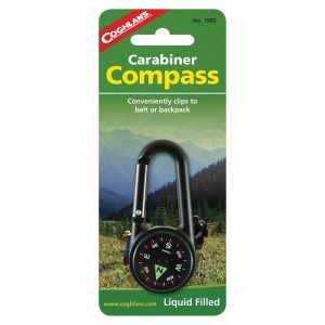
Coghlan’s Carabiner Compass
Accessories, Carabiners, Coghlan's, Navigation, Outdoor & Trekking$ 19.95The durable aluminum construction ensures it will follow you into the wild or just around town and get you back again. The luminous directional markers allow for navigating in low light and its compact size makes it easy to clip on a belt to keep it close for quick reference.This liquid filled compass comes with a handy built-in carabiner to make attaching it to a bag or pack quick and simple.
-

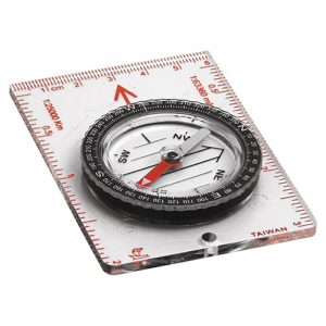
Coghlan’s Combination Compass
Accessories, Coghlan's, Navigation, Outdoor & Trekking$ 25.50Five map scales. Scaled magnetic dial & bezel ringLiquid filled housing with see-through folding base.
-
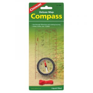
Coghlan’s Deluxe Map Compass
Accessories, Coghlan's, Navigation, Outdoor & Trekking$ 22.95The Deluxe Map Compass is lightweight and compact. It has a built-in magnifier and includes scales in millimeters and 1:25000 making it ideal for orienteering and general map reading.Featuring a liquid dampened needle with luminous pointer and a see-through base with rotating housing
SPECIFICATIONS:
Scales: 1:25000, 1:50000, and millimeters (1:1) Instruction booklet included Lanyard included -
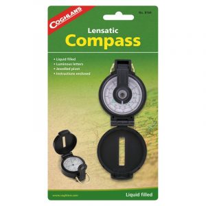
Coghlan’s Lensatic Compass
Accessories, Coghlan's, Navigation, Outdoor & Trekking$ 19.95Features a jeweled pivot and luminous lettersLiquid filled for fast readability with sturdy plastic case.
-
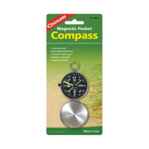
Coghlan’s Magnetic Pocket Compass
Accessories, Coghlan's, Miscellaneous, Navigation$ 18.95Navigate the wild unknown with absolute confidence using Coghlan's Magnetic Pocket Compass.
Its precision jewelled needle and positive stop lock offer superior directional accuracy, while its non-glare black luminous dial ensures easy reading in all lighting conditions. The chrome metal case provides a tough barrier against the elements, making this pocket compass an ideal companion for any outdoor excursion. Its compact size makes it the perfect addition to your everyday gear – get ready to explore without worry or hesitation! -
Coghlan’s Map Compass
Accessories, Coghlan's, Navigation, Outdoor & Trekking$ 19.95Base contains scales in inches, milimeter and 1:25,000. Jeweled needle and luminous pointer.Features include a see-through base and rotating, liquid filled housing.
-
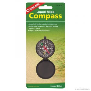
Coghlan’s Pocket Compass
Accessories, Coghlan's, Navigation, Outdoor & Trekking$ 12.95Adjustable capsule for direction setting memory arrow.Impact resistant case, jeweled needle with luminous pointer.
-

Coghlan’s Trail Compass
Accessories, Coghlan's, Navigation, Outdoor & Trekking$ 16.95The perfect backpacker's compass clips to your zipper or backpackAnd features a rotating bezel with direction setting arrow. Quickly check your bearings at a glance -
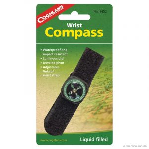
Coghlan’s Wrist Compass
Accessories, Coghlan's, Miscellaneous, Navigation, Outdoor & Trekking$ 13.95Adjustable strap.Waterproof and impact resistant, liquid filled compass with luminous dial
-

Coghlan’s Zipper Pull Thermometer/Compass
Accessories, Coghlan's, Miscellaneous, Navigation, Outdoor & Trekking$ 10.95General purpose compass with Fahrenheit & Celsius scale.Windchill chart on back. -
Sale
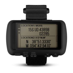
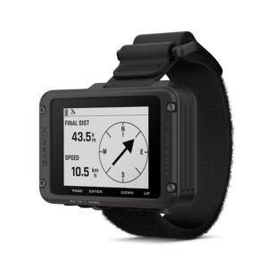
Garmin Foretrex 701 Ballistic Edition
Accessories, Garmin, Navigation, Watch / GPSThe durable, wrist-mounted GPS navigators built to military standards. Keep your bearings nearly anywhere with GPS, GLONASS and Galileo satellite systems. - Durable, constructed to military standards (MIL-STD-810G); night vision goggle compatible - Works with GPS, GLONASS and Galileo satellite systems to provide accurate positioning - Know where you are with navigation sensors, including 3-axis accelerometer, 3-axis compass and a barometric altimeter; smart notifications¹ allow your device to receive emails, texts and alerts - Foretrex 701 adds Applied Ballistics Elite software that calculates aiming solutions for long-range shooting - Battery life exceeds 48 hours in navigation mode, up to 1 week in UltraTrac™ mode and up to 1 month in watch modeNavigate the world hands-free with Foretrex 601 and Foretrex 701 with AB Elite software.
Tougher Than It Needs to Be
Foretrex 601 and 701 navigators are beyond durable. They’re built to military standards for thermal, shock and water performance (MIL-STD-810G). They also include tactical features such as compatibility with night vision goggles and Jumpmaster mode.Multi-GNSS Navigation Includes Galileo
Both Foretrex 601 and 701 work with 3 satellite navigation reception networks, including GPS, GLONASS and Galileo, to track your position in more challenging environments than GPS alone. Explore longer — battery life exceeds 48 hours in navigation mode and lasts up to 1 week in UltraTrac mode.Navigation Sensors Keep You on Track
To guide you on and off the beaten path, Foretrex 601 and 701 provide comprehensive navigation and tracking using GPS plus ABC (altimeter, barometer and compass) sensor capabilities. The built-in altimeter provides elevation data to accurately monitor ascent and descent, while the barometer can be used to predict weather changes by showing short-term trends in air pressure. The 3-axis electronic compass keeps your bearings, whether you’re moving or not.The Most Accurate Ballistic Solver Available
Foretrex 701 with AB Elite software is an excellent aid for hunters and target shooters. It comes equipped with Applied Ballistics Elite software to calculate aiming solutions for long-range shooting.Stay Connected
Smart notifications — available on both devices — let you receive emails, texts and alerts from your mobile device right on your wrist. Use the Garmin Connect™ Mobile app to initiate the LiveTrack¹ feature to allow others to follow your journey (within cellular coverage). Other connected features include automatic uploads to our Garmin Connect™ online fitness community and automatic software updates when paired to a mobile device.$ 899.00$ 764.15 -
Garmin Foretrex 801 GPS
Accessories, Categories, Garmin, Navigation, Watch / GPS$ 449.00It features an easy-to-read monochromatic display, upgraded multi-band GNSS, and advanced navigation sensors to help you explore with confidence. + Easy-to-read monochromatic screen + Multi-band GNSS + Night vision goggle compatible + Stealth mode + Plan adventures with Garmin Explore™ app + Kill SwitchThis wrist-mounted GPS navigator is built for the mission and beyond.
LONG BATTERY LIFE
Get up to 100 hours of battery life in navigation mode or up to 1000 hours in expedition mode; uses 2 field-replaceable AAA batteries (not included).DURABLE
Tested to military standards (MIL-STD-810) to withstand sand and dust, vibration, shock, temperature, altitude, humidity and more. The rugged design features an IPX7 water-resistant rating.TACTICAL FEATURES
Use stealth mode to stop storing and sharing GPS data and disable wireless connectivity. In case of security issues, hit the kill switch to erase the device memory. Use jumpmaster mode to calculate high-altitude release points in accordance with military guidelines.EASY-TO-READ SCREEN
The improved monochromatic screen is easy to read in a variety of lighting conditions, even with night vision goggles.NAVIGATION SENSORS
Navigate the terrain with advanced sensors, including a 3-axis accelerometer, 3-axis compass and barometric altimeter. Get improved position accuracy with upgraded multi-band GNSS.CONNECT YOUR DEVICES
Get smart notifications when linked with your compatible smartphone. Pair with your compatible inReach® satellite communicator, and view messages directly on the screen1. 1 Satellite subscription required. Some jurisdictions regulate or prohibit the use of satellite communication devices. It is your responsibility to know and follow all applicable laws in the jurisdictions where the device is intended to be used.SPECIFICATIONS
Physical & Performance:
Display Size 2.2″ diagonal Battery type 2 AAA batteries (not included) Display Resolution 320 x 240 pixels GPS Yes Dimension 7.4 x 4.3 x 2.3 cm (2.9″ x 1.7″ x 0.9″) Interface USB-C Waterproof IPX7 Weight 108 g (3.8 oz) with batteries Display Type Monochrome MIP Battery life Up to 100 hours in default GPS Mode Up to 1,000 hours in expedition mode High-sensitivity receiver No Maps & Navigation
Basemap No Navigation Routes 50 Navigation Track Log 10,000 Ability to add maps No Features
Send route selection to MapShare during trip No QZSS No Multi-frequency Positioning Yes Smart switching between Wi-Fi, Mobile and Satellite with Garmin Messenger app No Dual grid coordinates Yes Send waypoints to MapShare during trip No inReach weather No Active Weather No Contacts No Rinex logging No inReach remote widget No Pairs with Garmin Connect™ Mobile Yes Touchscreen No LED beacon flashlight No inReach remote compatible No Sun and moon information Yes Virtual keyboard for custom messaging No MapShare compatible with tracking No KILL SWITCH Yes Night vision mode Yes IRNSS No Geocaching-friendly No Send and receive text messages to other inReach device No Automatic routing (turn by turn routing on roads) for motorized vehicles No Send and receive group messages No GLONASS Yes Send and receive text messages to SMS and email No Frequency band No Displays national, state and local parks, forests, and wilderness areas No Smart notifications on handheld Yes Connect IQ™ (downloadable watch faces, data fields, widgets and apps) No Custom maps compatible No Compatible with Earthmate No Courses 500 Dog tracking No Connections Wireless Connectivity Yes (Bluetooth®, ANT+®) LiveTrack No Exchange locations with other inReach device No Vibration alert No Point-to-point navigation Yes Picture viewer No Barometric altimeter Yes SBAS No Weather No XERO™ Locations No Interactive SOS No VOX (voice activation) No BeiDou No Ballistics solver No Automatic routing (turn by turn routing on roads) for outdoor activities No TracBack® Yes GPS compass (while moving) Yes Includes detailed hydrographic features (coastlines, lake/river shorelines, wetlands and perennial and seasonal streams) No QuickFit™ watch band compatible Yes (26 mm) Multi-band frequency No Includes searchable points of interests (parks, campgrounds, scenic lookouts and picnic sites) No Hunt/fish calendar Yes Compass Yes (tilt-compensated 3-axis) Compatible with Garmin Explore™ app Yes Tracks 100 Compatible with Garmin Messenger app No Galileo Yes Garmin Pilot™ app compatible No Garmin Explore website compatible Yes Area calculation Yes MIL-STD-810 Yes (thermal, shock, water); bare unit only Compatible with AB Synapse No Location reporting (send and receive GPS positions) No Stealth Mode Yes VIRB® Remote No -
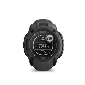
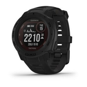
Garmin Instinct 2X Solar
Accessories, Garmin, Navigation, Watch / GPS$ 769.00This big, rugged GPS smartwatch is tough enough to keep up with you and bold enough to fit your style. Its expansive solar charging lens keeps a larger battery going longer— powering advanced training features, a built-in flashlight, multi-band GNSS, health/wellness monitoring sensors and much more.WHATEVER YOU DO, OWN IT
 This watch is tough, which means no holding back.
 Keep your experiences going with unlimited battery life in smartwatch mode with solar charging.
 Train your way with built-in sports apps at the wrist.
 When it gets dark, the built-in LED flashlight helps keep you going.
 Smart notifications so you don’t miss out on what matters.
 Understand your body better with 24/7 health monitoring.
ENGINEERED FOR ENDURANCE
This ultratough watch features a solar charged display and rugged 50 mm polymer case. It’s water-rated to 10 ATM and tested to U.S. military 810 standards for thermal, shock and water resistance.DESIGNED TO DO YOU
With a design built for action and the features to support your high-energy lifestyle, this watch is always ready for adventure. Plus, its bold styling clearly shows the world that you do things your own way.GET MORE BATTERY OUT OF LIFE
Go longer than ever with solar charging with unlimited battery life in smartwatch mode. Plus, power manager lets you extend battery life by controlling what settings and sensors draw power. SPECIFICATIONS:Physical & Performance
Display Size custom, two-window design; 27 x 27 mm (1.1″ x 1.1″) Display Type Monochrome, sunlight-visible, transflective memory-in-pixel (MIP) Battery life Smartwatch: 40 days unlimited with solar* GPS: 60 hours; 145 hours with solar** All Satellite Systems: 40 hours; 65 hours with solar* All Satellite Systems + Multi-Band: 27 hours; 36 hours with solar** Max Battery GPS Mode: 150 hours; unlimited with solar** Expedition GPS Activity: 60 days; unlimited with solar* Battery Saver Watch Mode: 100 days; unlimited with solar* *Solar charging, assuming all-day wear with 3 hours per day outside in 50,000 lux conditions **Solar charging, assuming use in 50,000 lux conditions Display Resolution 176 x 176 pixels GPS Yes Weight 67 g Maps & Navigation
Memory/History 64 MB Features
STR3AMUP! PC tool for streaming biometrics No Multi-frequency Positioning Yes 3-axis compass with HSI (horizontal situation indicator) No Touch and/or button lock Yes Preloaded ski resort maps No Wind speed and direction (requires connection to Garmin Golf app) No Live Event Sharing No SLEEP Yes Green Contours (with Garmin Golf membership) No Battery saver (customizable low power watch) Yes Swing Tempo No Plays and controls watch music No APNEA mode No Ground contact time and balance Yes (with compatible accessory) Density altitude calculator No Critical swim speed No Training load focus No Compatible with Varia Vision™ (head-mounted display) No HR alerts Yes Training effect (anaerobic) Yes Abnormal heart rate alerts yes (high and low) Easy break planning No Vertical speed Yes Lactate threshold Yes (with compatible accessory) Workout tutorials No Number of transmitters supported No MTB Grit & Flow Yes Customizable data pages Yes Configurable lap alerts Yes Incident Detection during select activities Yes Physio TrueUp Yes Custom alerts Yes NEXRAD on moving map No Back to start Yes Vertical oscillation and ratio Yes (with compatible accessory) Altimeter with adjustable baro setting No Physical size 50 x 50 x 14.5mm Fits wrists with a circumference of 145-228 mm Move bar (displays on device after a period of inactivity; walk for a couple of minutes to reset it) Yes Live Delta Time No Automatic altitude adjustment No Bezel Material Fiber-reinforced polymer Hazards and course targets Yes Truck driver workouts No TruSwing™ compatible No UltraTrac mode Yes VO2 Max (Trail Run) Yes Up Ahead No Preloaded race tracks No Pulse Ox Blood Oxygen Saturation Monitor Yes Relaxation Breathing Timer Yes % HR max Yes In Case of Emergency (I.C.E.) No Gas time remaining No Case material Fiber-reinforced polymer Water rating 10 ATM Subwave™ Support No Audible alerts No Color display No Multiple bike profiles No Rest timer No Wrist-based heart rate (constant, every second) Yes Find My Phone Yes PrePass weigh station notifications and bypass decisions No Stride length (real time) Yes (with compatible accessory) Bike lap and lap maximum power (with power sensor) Yes Open-water swim metrics (distance, pace, stroke count/rate, stroke distance, swim efficiency (SWOLF), calories) Yes training effect Yes Spectator messaging No Advanced workouts Yes Charging method Garmin proprietary plug charger TRENDLINE™ POPULARITY ROUTING No Strava Live Segments No Boundary enter/exit No training readiness Yes Timer Yes Courses Yes Respiration rate (during exercise) Yes Wirelessly receive flight plans from Garmin Pilot™ No Intensity minutes Yes Interval training Yes MOS & Meteogram No Alerts (triggers alarm when you reach goals including time, distance, heart rate or calories) Yes Pairs with Garmin Connect™ Mobile Yes Touchscreen No Virtual starting line No Preloaded topographical maps No Sun and moon information Yes Automatically saves dive entry and exit locations No Power guide No HRV stress test (measures your heart rate variability while standing still, for 3 minutes, to provide you with an estimated stress level; the scale of this is 1 to 100; low scores indicate lower stress levels) No Sight 'N Go Yes Location tracking No Pulse Ox blood oxygen saturation Yes Projected waypoint Yes Bread crumb trail in real time Yes Customizable activity profiles Yes Auto start/end dive No REFERENCE POINT Yes SatIQ™ Technology No Connect IQ™ (downloadable watch faces, data fields, widgets and apps) Yes Cadence (provides real-time number of steps per minute) Yes Controls smartphone music Yes Power meter compatible Yes LED flashlight Yes Improved recovery time Yes APNEA hunt mode No 60-minute activity goal No Manual multisport activities Yes Chores No Moving Map with aviation airports, navaids, roads, bodies of water and more No Point-to-point navigation Yes Anchor Alarm No Gauge mode No PacePro™ Pacing Strategies No Course- and weather-specific race predictor No Yardage to layups/doglegs Yes TAF (Terminal Aerodrome Forecast) No Auto Pause® Yes Running dynamics Yes (with compatible accessory) Esports Activity No Full vector map No BODY BATTERY™ ENERGY MONITOR Yes BLUETOOTH phone calling and voice assistant support No Accelerometer Yes Recovery time Yes Custom dive data screens No Drill logging (pool swim only) Yes Preloaded with 43,000 courses worldwide No Track timer No Strap material Silicone Jet lag adviser No Race App No Round timer/odometer Yes Smart trainer control Yes Heat and altitude acclimation Yes Cardio workouts Yes Connected GPS No Performance condition Yes Galileo Yes Distance traveled Yes Manual lap Yes GPS-based distance, time and pace Yes Text messaging No Realtime stamina No Running power Yes Nitrox support No Assistance Yes Race predictor Yes Stealth Mode No Pairs with Garmin Golf app Yes Auto lap splits No "Repeat on" rest timer (pool swim only) Yes Pilates workouts Yes GPS coordinates Yes Lap Time Repeatability Score (LTR) No Air integration No Audio prompts Yes Auto CourseView updates Yes Downloadable training plans Yes Stocks No Measures shot distance (calculates exact yardage for shots from anywhere on course) manual Run/Walk/Stand detection Yes Closed Circuit Rebreather (CCR) No Heart rate from external HRM (real-time during rests, interval and session stats during rests, and automatic heart rate download post-swim) Yes Compatible with Varia™ radar (rear-facing radar) Yes Task timers (2, 5, 10, 15, 20 and 30 minutes) No Pool swim workouts Yes Assistance Plus No Multi-gas mode No Music storage No Race an Activity Yes KILL SWITCH No Hot keys Yes Single-gas mode No Activity history on watch Yes On-screen workout animations No Auto max HR Yes DAILY SUGGESTED WORKOUTS Yes Foot pod capable Yes Compatible with Vector™ and Rally™ (power meters) Yes Phone-free text messaging No Tournament legal Yes Incident detection alert on phone for wearables No Race an activity Yes Finish time Yes Elevation profile Yes PlaysLike distance No Aviation Alerts No Virtual Partner Yes VO2 Max (Run) Yes Relaxation reminders No Reminder alerts No Wind meter compatible No Race glance/widget No TRAINING LOAD Yes Chronograph No Available gym activity profiles Strength, HIIT Cardio and Elliptical Training Stair Stepping, Floor Climbing, Indoor Rowing, Pilates, Yoga, Breathwork Ambient light sensor No Touch-targeting (touch target on display to see the distance to any point) No Stroke type detection (freestyle, backstroke, breaststroke, butterfly) (pool swim only) Yes In-flight Pulse Ox No Yardage to F/M/B (distance to front, middle and back of green) Yes Calendar Yes Barometric altimeter Yes Unlock new step icons No On-device Connect IQ™ Store No Weather Yes Auto Lap® Yes Sunrise/sunset times Yes Tides Glance Yes Pacing alerts (pool swim only) No Floors climbed Yes Respiration Rate (24x7) Yes Gas consumption rate No % HRR Yes Ballistics solver No On-Screen Workout Muscle Map No AUTO REST No Basic rest timer (up from 0) (pool swim only) Yes Available outdoor recreation profiles Hiking, Indoor Climbing, Bouldering, Climbing, Skiing, Snowboarding, Backcountry Snowboarding, XC Classic Skiing, Backcountry Skiing, Stand Up Paddleboarding, Rowing, Kayaking, Surfing, Hunting, Kiteboarding, Windsurfing, Snowshoeing, Fishing, Horseback Riding, Tennis, Tactical, Obstacle Course Racing TracBack® Yes Advanced cycling dynamics yes (in app) Handicap scoring No Primary benefit (Training Effect labels) Yes HR zones Yes Auto rest (pool swim only) Yes Stat tracking (strokes, putts per round, greens and fairways hit) Yes Connectivity Bluetooth®, ANT+® Improved interval (includes open repeats, intervals data page, rest screen and auto detection) No Sleep Score and Insights Yes Custom targets No Downloadable cartography support No Available run profiles Running, Outdoor Track Running, Treadmill Running, Indoor Track Running, Trail Running Run workouts Yes Stopwatch Yes Worldwide airport database(s) No Waypoint information page No GPS speed and distance Yes Round-trip course creator (running/cycling) No Area calculation Yes Find My Watch Yes Automatic club tracking compatible (requires accessory) Yes Connext avionics connectivity No Preloaded road and trail maps No Rest Timer (Ultra Run only) No Unified training status Yes VIRB® Remote Yes Smartphone compatibility iPhone®, Android™ Dual grid coordinates Yes HRM running pace and distance Yes Expedition GPS Activity Yes TrueUp™ Yes Morning report Yes Multiple time zones with Zulu/UTC No Trimix support No Compatible with Varia™ lights Yes Two-way voice calls No Thermometer Yes Hydration yes (in Garmin Connect™) Alarm clock Yes Group LiveTrack No Gyroscope Yes Underwater wrist-based heart rate Yes Countdown start (pool swim only) Yes Health Snapshot Yes ClimbPro™ Ascent Planner No Truck plaza loyalty programs No Night vision mode No Available swim profiles Pool Swimming, Open Water Swimming Tempo Training No Power Modes - customizable in-activity battery settings Yes Move IQ™ Yes Speed and cadence sensor support (w/sensor) Yes Do not disturb/School mode No Garmin Elevate™ wrist heart rate monitor Yes Tides No GLONASS Yes Smart Notifications Yes Garmin Pay™ Yes HRV Status Yes Automatic daylight saving time Yes Yoga workouts Yes Depth sensor No Time/date yes Sync dive log to Garmin Dive™ Mobile app No Rewards (coins) No VIRTUAL CADDIE No Calories Burned Yes Toe-to-Toe™ Challenges app Yes (optional Connect IQ Toe-to-Toe™ Challenges app) Garmin Live Segments No HR broadcast (broadcasts HR data over ANT+™ to paired devices) yes (using ANT+) Fly activity emergency mode No Total ascent/descent Yes Auto multisport activities Yes Last race summary No Cycle Map (routable cycling-specific street map) No Power curve and % FTP workouts No PinPointer No Step counter Yes METAR (Meteorological Aerodrome Report) No Quick Release bands No Trail run auto climb Yes Barometric trend indicator with Storm Alert Yes Automatic rep counting Yes LiveTrack Yes HR calories Yes Grade-adjusted pace Yes Tides Yes Time and distance alerts Yes Garmin Connect™ Challenges app Yes (optional Connect IQ app) XERO™ Locations Yes All-day stress Yes Tack assist mode No Compatible with dēzl™ OTR truck navigators No Worldwide NAVAID and Intersection database(s) No Available cycling profiles Bike, Road Bike, Mountain Bike, Gravel Bike, Bike Commute, Bike Tour, eBike , Bike Indoor, Cyclocross, Triathlon HIIT workouts Yes Future elevation plot Yes QuickFit™ watch band compatible yes (26 mm) Games No Orienteering No Text response/reject phone call with text (Android™ only) Yes Around Me mode No Realtime settings sync with Garmin Connect™ mobile Yes Hunt/fish calendar No Course guidance Yes GPS Time Sync Yes Countdown timer No Auto scroll Yes Analog hands No Compass Yes Digital scorecard yes Lens Material Power Glass™ NextFork™ navigation No Green View with manual pin position Yes Strength workouts Yes Distance to destination Yes Voice messaging No Women's Health yes (in Garmin Connect™) Training status Yes Pool swim metrics (lengths, distance, pace, stroke count, swim efficiency (SWOLF), calories) Yes Daily resting heart rate Yes Auto goal (learns your activity level and assigns a daily step goal) Yes Garmin AutoShot™ Yes FITNESS AGE yes (in app) FTP (Functional Threshold Power) Yes Dive ascent/descent rate indicator No Built-in barometer and tide tables No -
Platatac Hard Compass Cover
Accessories, Navigation, Platatac$ 19.95A cover designed to protect your Silva Compass
The Platatac Hard Compass Cover provides total protection for your Silva 55-6400 360 MS MILS Compass. It is crafted from tough plastic that can keep the delicate prism and dial safe from water, dust, and impact. The cover fits snugly over the compass to ensure a secure fit, while a lanyard loop lets you attach it wherever you need it most.Features:
– Viewing window for the prismatic sighting system – Lanyard Loop – Made from strong plastic -
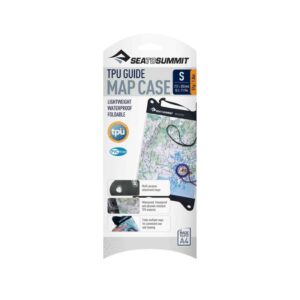
Sea to Summit TPU Guide Map Case
Accessories, Navigation, Sea to Summit$ 41.99 – $ 51.99It's hard to read a wet map—keep yours dry and legible with this waterproof, foldable and durable map case.Features: - Totally welded construction—no stitches - Individually tested—water and dust-proof - Super strong press-lock closure - Anchor points on corners for versatile attachment - Detachable neck strap - Flexible and crease resistant, it can be folded to fit in a pocket - UV resistant for superior long lasting clarity - Freeze-proof—will not crack in extreme cold - Abrasion resistant, high strength, PVC-free, TPU material Specifications: MATERIAL: 100% Nylon fabric + 100% TPU window -
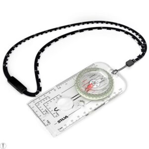
Silva Compass 55-6400/360 MS MILS
Accessories, Navigation, Silva$ 309.99The Silva 55-6400/360 MS Mils Compass replaces the NSN’d Silva 54/6400B Compass. As a result, it has superior accuracy and readability.
The Silva 55-6400 360 MS Mils Compass is a vital tool for anyone who wants precision and versatility in their outdoor missions. This advanced compass features an optical precision sighting system and a SILVA 1-2-3 SYSTEM compass in the same unit, providing unbeatable accuracy no matter where you are. In addition, the 55 compass allows you to take bearings with accuracy to within half a degree. It also incorporates a luminous graduation ring and markings, which allow easy compass reading even in the dark. With its daylight flashlight activation, this compass will provide up to four hours of light. The included Slope card will help you calculate avalanche risk and determine how challenging your journey will be. Scale Lanyard consists of 2 scales (1:25, 1:50), soft, bendable and easy to place directly on to your route on the map. Note: This is a Magnetic South – Southern Hemisphere compass. -

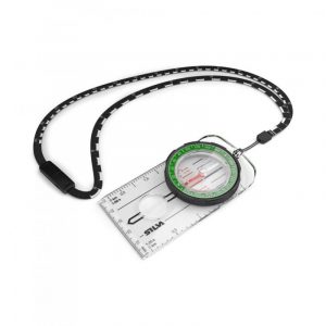
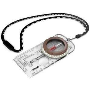
Silva Compass Field MS
Accessories, Navigation, Silva$ 44.99Introducing the Silva Compass Field MS, an upgraded version of the classic SILVA Field compass.
This reliable navigation tool features a base plate with map measuring scales in mm and compatibility with 1:50,000 and 1:25,000 maps. The DryFlex™ rubber bezel provides enhanced comfort and grip for precise handling in any weather condition. Additionally, the compass comes equipped with a detachable safety release lanyard for added security during your outdoor adventures. Trust the Silva Compass Field MS to be your trustworthy companion for all your navigation needs.
-
Silva Expedition MS
Accessories, Navigation, Silva$ 104.99Equipped with a base plate featuring map-measuring scales in millimeters, along with 1:50,000 and 1:25,000 scales, the Ranger S offers precise navigation capabilities. Enhanced with 45-degree angle assistance on the mirror sighting function, this versatile compass is an essential tool for dedicated compass users. Its soft and flexible lanyard allows easy placement directly onto your route on the map. The redesigned graphics feature a distinct arrow (Ranger) and modern font in green and black shades to blend seamlessly with outdoor gear. For adventurers seeking a reliable yet functional compass, the Ranger proves to be an ideal choice. The integrated magnifier ensures clear visibility of every detail on the map. When determining direction over long distances is paramount, opt for our Ranger S mirror sighting compass. The SILVA 1-2-3 System® enables more accurate directional readings without having to divert your gaze from the compass to the terrain.Showcases a DryFlex™ grip for effortless handling and houses a convenient use-anywhere declination scale within its capsule.
Features:
NAVIGATION SYSTEM: 360 MAGNIFIER: Yes DECLINATION: Yes MAP SCALES: Yes GPS SCALES: Yes NIGHT USE: Yes CLINO METER: Yes WEIGHT: 50 g -
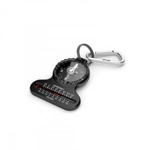
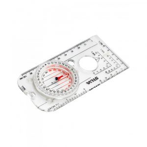
Silva Pocket Compass
Accessories, Navigation, Silva$ 21.99With its small size and precise needle, this is the perfect compass to to bring along your hike. Not for advanced navigation, but a great aid if you need to find the right direction or a backup for a more advanced compass. It fits right in your pocket and comes with a carabiner hook for attachment as well as a thermometer to keep you aware of your environment’s shiftings. Keep this compass in your pocket at all times and you’ll be safe!A small curvy compass with thermometer and cardinal directions.
Features:
Article number: 37617 Carabiner hook: Attach to clothing, bag or rucksack Other: Thermometer with Fahrenheit and Celsius Size: 57x47x9mm Weight: 16g -
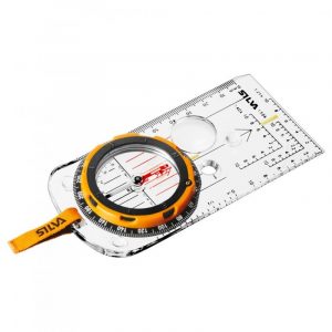
Silva Ranger MS
Accessories, Navigation, Silva$ 64.99Introducing the Silva Ranger MS, a must-have companion for serious compass users.
Engineered for precision and reliability, this go-anywhere tool is designed to excel in any outdoor environment. The Silva Ranger boasts DryFlex™ grip, ensuring easy handling even in challenging conditions. Equipped with a use-anywhere declination scale inside the capsule, a magnifying lens, and base plate map measuring in mm and scales of 1:50,000 and 1:25,000, it offers unparalleled functionality for navigating with confidence. Whether you're trekking through rugged terrains or embarking on wilderness adventures, the Silva Ranger MS is your trusted navigation partner, empowering you to explore with unwavering accuracy.
-
Silva Ranger S MS
Accessories, Navigation, Silva$ 99.99The Silva Ranger S showcases a DryFlex™ grip for effortless handling and houses a convenient use-anywhere declination scale within its capsule.
Equipped with a base plate featuring map-measuring scales in millimeters, along with 1:50,000 and 1:25,000 scales, the Ranger S offers precise navigation capabilities.
Enhanced with 45-degree angle assistance on the mirror sighting function, this versatile compass is an essential tool for dedicated compass users.
Its soft and flexible lanyard allows easy placement directly onto your route on the map. The redesigned graphics feature a distinct arrow (Ranger) and modern font in green and black shades to blend seamlessly with outdoor gear.
For adventurers seeking a reliable yet functional compass, the Ranger proves to be an ideal choice. The integrated magnifier ensures clear visibility of every detail on the map.
When determining direction over long distances is paramount, opt for our Ranger S mirror sighting compass. The SILVA 1-2-3 System® enables more accurate directional readings without having to divert your gaze from the compass to the terrain.
Features:
-Attachment: Detachable safety-release scale lanyard -Declination adjustment: Declination scale inside capsule -Illumination: Luminous markings -Scales: 1:25k, 1:50k, Lanyard; 1:25, / 1:50, mm, inch -Weight: 58g -
Silva Ranger SL MS
Accessories, Navigation, Silva$ 79.99A compact sighting compass designed for the modern explorer.
Whether you need a reliable backup compass or want an always-ready navigation tool, the SILVA Ranger SL is a perfect choice. This small yet powerful compass features a built-in sun dial and can be conveniently attached to your jacket using a safety pin, enabling hands-free navigation on-the-go. Ideal for serious compass users, the Silva Ranger SL MS is a versatile go-anywhere tool that ensures accurate direction finding wherever your adventures take you.
Features:
NAVIGATION SYSTEM: 360 MAP SCALES: Yes NIGHT USE: Yes MIRROR SIGHTING: Yes WEIGHT: 23 g -
Sale
Valhalla Leader Mud Model Kit
Accessories, Admin, Cadet Gear, Navigation, Pouches & Platforms, Valhalla$ 69.95With 68 Platoon/Section/Support and Enemy position markers and an assortment of other location and path identifying items it's the most complete Mud model kit on the market. Essential for any leader!The VALHALLA LEADER MUD MODEL KIT is an essential piece of kit for ALL section and Platoon Commanders.
Features:
- Australian Made - 68 Assorted Platoon, Section, Support and Enemy positions symbols. Made of durable PP that will last in any conditions - 8 x White paddle marker (capacity to be drawn on and erased) - 4 x Colored position or task markers. Red, Green, Blue, Yellow (capacity to be drawn on and erased) - 3m Length of black paracord - 3m Length of blue Paracord - 3m x Length of Coyote Paracord - 3m x Length of red Paracord - 1 x Pencil - 1 x Eraser - 4 x colored white board marker If attachment to molle gear is required. Click here to purchase Malice clips to go with your mud model kit pouch
-
World Wide Maps Binna Burra – O’Reillys Map
Accessories, Navigation, World Wide Maps$ 25.50Map includes all the bush walks and the Great Walk from Binna Burra to O'Reilly's, as well as The Lost World, Stinson Wreck and Westrays Grave. One map does it all. 1:25,000 scale.Topographic map (A1 size) Binna Burra to O'Reilly?s to Point Lookout on the Scenic Rim in the Gold Coast Hinterland.
-
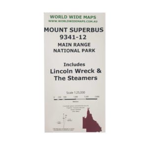
World Wide Maps Count Superbush Bush Walks Map
Accessories, Navigation, World Wide Maps$ 25.50Mount Superbus, the Steamers, the Lincoln Wreck and north to Mount Huntley.This map is a full size A1 topographic map at 1:25,000 standard map number 9341-12. Includes information about some walks and camp sites and how to get there. -
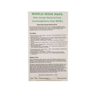
World Wide Maps Cunninghams Gap Bush Walks – Main Range
Accessories, Navigation, World Wide Maps$ 25.50- Box Forest track - Rainforest circuit - Gap Creek Falls track - Palm Grove circuit - Mount Cordeaux track - Bare Rock track/ Morgans Walk - Mount Mitchell track - Pioneer Graves track - Moss's Well track - Heritage trail - Mount Mathieson trail The map comes as compact shirt pocket sized (A3) double sided and folded topographic maps of the Cunninghams Gap–Main Range National Park area. The maps display the best available contours, tracks and the latest topographic information. The reverse side is a general location topo/road map and the map includes general instructions on how to get to the area. The map data is sourced from the latest Queensland Government topographic datasets through QTopo and the Government's Open Data Strategy.1:18,000 scale topographic map of Cunninghams Gap and Main Range bush walking tracks:
-
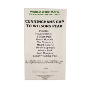
World Wide Maps Cunninghams Gap to Wilsons Peak Map
Accessories, Navigation, World Wide Maps$ 25.50One great topographic map at 1:50,000 scale showing the whole Main Range from Cunninghams Gap to Wilsons Peak.Includes Mount Mitchell, Mount Huntley, The Steamers, Mount Superbus and Lake Moogerah. -
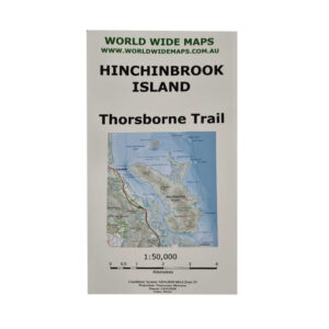
World Wide Maps Hinchinbrookk Island – Thorsborne Trail 1:50000 Scale
Accessories, Navigation, World Wide Maps$ 25.50And covering most of the rest of the island except the North East and North West points. The map has the camping sites and toilets marked and information about the walk, as well as link to national parks website for further information.An A1 size folded paper topographic map at 1:50,000 scale covering the entire Thorsborne Trail on Hinchinbrook Island.
-

World Wide Maps Lost World and Stinson Wreck Map
Accessories, Navigation, World Wide Maps$ 25.501:25,000 scale and full sized topo map for bush walking to both the Stinson Wreck and Lost World and the areas between them.All on one map sheet. -
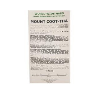
World Wide Maps Mount Coot-Tha Map
Accessories, Navigation, World Wide Maps$ 25.50A full size (A1) topographic map at 1:10,000 scale of Mount Coot-tha Brisbane.Information about the walks and the trails marked. -
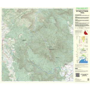
World Wide Maps Mt. Bargle Frere Trail Map
Accessories, Navigation, World Wide MapsA full sized 1:36,000 scale topographic map of Mount Bartle Frere Trail showing the trail, information about the trail and how to get there, camp sites, and all of the normal topographic features. Climb Queensland's highest mountain with the best map for it ever published!$ 25.50 -
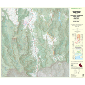
World Wide Maps Springbrook Binna Burra Topographic Map
Accessories, Navigation, World Wide MapsTopographic Map (A1 size) Springbrook to Binna Burra Great Walk—Showing walking tracks including the Great Walk between Springbrook and Binna Burra on the scenic rim in the Gold Coast Hinterland, South East Queensland. 1:25,000 scale.$ 25.50 -
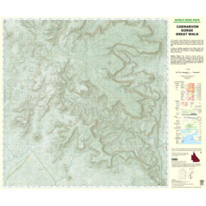
World Wide Maps Carnarvon Gorge Great Walk Map
Accessories, Navigation, World Wide Maps$ 25.50Full size (A1) topographic map at 1:50,000 scale of the entire Carnarvon Great Walk.This is the best traditional topographic map of the Great Walk and the topography of the gorge and tablelands. -

World Wide Maps Girraween Camps & Walks Map
Accessories, Navigation, World Wide Maps$ 25.50Derived from the latest government databases with information about walks, camping and caravan information and links to book your campsite. This map is intended to replace the Hema Girraween map and the government Girraween topo, which are both no longer in production.World Wide Maps have produced a 1:25,000 scale full size topographic map
-
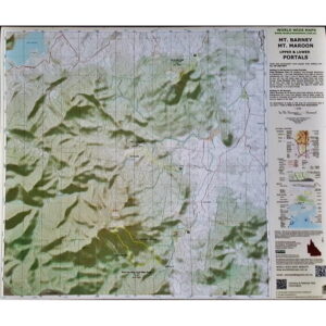
World Wide Maps Mt. Barney Mt. Maroon Upper & Lower Portals Map
Accessories, Navigation, World Wide Maps$ 25.50Key walks marked with short descriptions and advice on how to get there. This is a full sized (A1) 1:25000 scale topographic map with 3 of South East Queensland's most popular walking areas all on one topo map. This is the SEQ bushwalker's must have map! There are numerous walks contained within this topographic map area.Mount Barney, Mount Maroon and Upper and Lower Portals all on one topographic map!
-
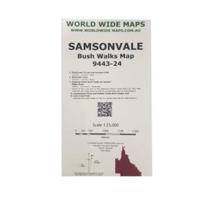
World Wide Maps Samsonvale Bush Walks Map 9443-24
Accessories, Navigation, World Wide Maps$ 25.50This print on demand 1:25,000 scale topo map Samsonvale 9443-24, replaces the old published map (1981).The standard topo map has been enhanced by World Wide Maps with 5 bush walks highlighted. 1. Rainforest Circuit and Greenes Falls 2. Westside Track 3. England Creek Bush Camp via Joyners Ridge Road 4. Lepidozamia Road and Kobble Creek Bush Camps 5. Love Creek Falls The map covers part of South D'aguilar National Park, Brisbane Forest Park. -
Sold out
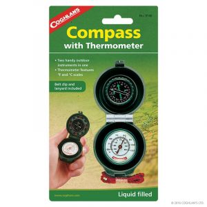
COGHLAN’S COMPASS THERMOMETER
Accessories, Coghlan's, Navigation, Outdoor & Trekking$ 19.95Two handy outdoor instruments in one. Liquid filled compass with luminous dial. “Homefinder” instructions on package. Thermometer features °F and °C scales. Belt clip and lanyard included. -
Sold out
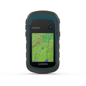
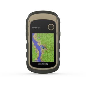
Garmin eTrex 22x
Accessories, Garmin, Navigation, Watch / GPSExplore Confidently with the Reliable Handheld GPS. - 2.2" sunlight-readable color display with 240 x 320 display pixels for improved readability - Preloaded with TopoActive maps with routable roads and trails for cycling and hiking - Support for GPS and GLONASS satellite systems allows for tracking in more challenging environments than GPS alone - 8 GB of internal memory plus a microSD card slot - eTrex 32x adds a 3-axis compass and barometric altimeter - Battery life: up to 25 hours in GPS mode with 2 AA batteries eTrex 22x and eTrex 32x offer the same ease-of-use, durability and affordability that the eTrex handheld GPS series is known for—along with preloaded TopoActive maps. These devices are perfect for ATVs, bicycles, boats or hiking. See the Way eTrex 22x and 32x offer enhanced 2.2", 65K color, sunlight-readable displays. Durable and water resistant, these handhelds are built to withstand the elements. Explore the Terrain The eTrex 22x and 32x handheld devices come preloaded with road-routable TopoActive maps that feature streets and trails so you can take the journey off the grid. Now you can know your surroundings—such as waterways, natural features as well as buildings, international boundaries and more. You can also find thousands of points of interests, including shops, restaurants, universities, car parks and accommodations. Keep Your Fix The eTrex series uses both GPS and GLONASS satellite systems so the receiver has the ability to track in more challenging environments than GPS alone. eTrex 32x adds a 3-axis compass and barometric altimeter, making it easy for you to keep your bearings. Satellite Imagery Both devices support BirdsEye Satellite Imagery (subscription required), so you can download and integrate satellite imagery with your maps. Find Fun eTrex 22x and eTrex 32x support paperless geocaching. Upload GPX files straight to your device, and view key information such as location, terrain and hints from Geocaching.com Go Anywhere With an array of compatible mounts, eTrex is designed as a handheld—for use on ATVs or bicycles, in boats or on foot. Use the auto mount capability and City Navigator NT maps for turn-by-turn driving directions, or use the rugged mount for your motorcycle or ATV. Wherever you think you might take eTrex, it has the mapping and mounts to get you there.$ 339.00 -
Sold out
Garmin eTrex 32x
Accessories, Garmin, Navigation, Watch / GPS$ 529.00Explore Confidently with the Reliable Handheld GPS- 2.2" sunlight-readable color display with 240 x 320 display pixels for improved readability - Preloaded with TopoActive maps with routable roads and trails for cycling and hiking - Support for GPS and GLONASS satellite systems allows for tracking in more challenging environments than GPS alone - 8 GB of internal memory plus a microSD card slot - eTrex 32x adds a 3-axis compass and barometric altimeter - Battery life: up to 25 hours in GPS mode with 2 AA batteries eTrex 22x and eTrex 32x offer the same ease-of-use, durability and affordability that the eTrex handheld GPS series is known for along with preloaded TopoActive maps. These devices are perfect for ATVs, bicycles, boats or hiking. See the Way eTrex 22x and 32x offer enhanced 2.2", 65K color, sunlight-readable displays. Durable and water resistant, these handhelds are built to withstand the elements. Explore the Terrain The eTrex 22x and 32x handheld devices come preloaded with road-routable TopoActive maps that feature streets and trails so you can take the journey off the grid. Now you can know your surroundings—such as waterways, natural features as well as buildings, international boundaries and more. You can also find thousands of points of interests, including shops, restaurants, universities, car parks and accommodations. Keep Your Fix The eTrex series uses both GPS and GLONASS satellite systems so the receiver has the ability to track in more challenging environments than GPS alone. eTrex 32x adds a 3-axis compass and barometric altimeter, making it easy for you to keep your bearings. Satellite Imagery Both devices support BirdsEye Satellite Imagery (subscription required), so you can download and integrate satellite imagery with your maps. Find Fun eTrex 22x and eTrex 32x support paperless geocaching. Upload GPX files straight to your device, and view key information such as location, terrain and hints from Geocaching.com Go Anywhere With an array of compatible mounts, eTrex is designed as a handheld—for use on ATVs or bicycles, in boats or on foot. Use the auto mount capability and City Navigator NT maps for turn-by-turn driving directions, or use the rugged mount for your motorcycle or ATV. Wherever you think you might take eTrex, it has the mapping and mounts to get you there. -
Sold out
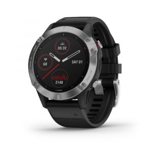
Garmin Fenix 6
Accessories, Garmin, Navigation, Watch / GPS$ 999.00With its always-on 1.3" display, the Fenix 6 boasts an impressive 18% larger screen compared to previous Fenix models, providing crystal-clear visibility in any conditions. This GPS multisport watch is not just a timepiece; it's a reliable companion for your most daring expeditions. Tested to U.S. military standards for thermal, shock, and water resistance, the Fenix 6 is built to endure the harshest environments. Its robust construction ensures unmatched durability, making it the perfect choice for those who demand uncompromising performance from their gear. Unleash your full potential and conquer new frontiers with the Garmin Fenix 6 - where cutting-edge technology meets rugged reliability. Elevate your outdoor pursuits with confidence and precision, only with the unmatched resilience of the Fenix 6. Pro Edition: Enables features on the watch such as Trendline Popularity Routing, PacePro, ski maps and the ability to preload music. Sapphire Edition: Pro Edition features, plus a scratch-resistant sapphire lens. Solar Edition: Versions with Power Glass lenses that harvest solar energy.Experience the ultimate in outdoor adventure with the Garmin Fenix 6.
Features:
SPORTS APPS Use preloaded activity profiles for trail running, swimming, running, biking, hiking, rowing, skiing, golfing and more. POWER MANAGER View how various settings and sensors impact your watch's battery life, so you can make battery-extending changes on the fly. WRIST-BASED HEART RATE The watch constantly samples your heart rate1 and will alert you if it stays too high or too low while you're at rest. It also helps gauge how hard you work during activities. Even underwater. BODY BATTERY ENERGY MONITOR Optimise your body's energy reserves, using heart rate variability, stress, sleep and other data to gauge when you're ready to be active or when you may need to rest. PERFORMANCE METRICS View advanced training metrics that include running dynamics, heat- and altitude-adjusted VO2 max, recovery advisor and more. BATTERY LIFE Internal, rechargeable lithium battery provides up to 14 days of battery life in smartwatch mode, 36 hours in GPS mode and up to 48 days in battery saver mode. Case Size: 47mm For full features and specifications, please visit Garmin's Website. -
Sold out
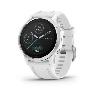
Garmin Fenix 6S
Accessories, Garmin, Navigation, Watch / GPS$ 1,149.00 – $ 1,299.00For durability in any environment, fenix 6S is tested to U.S. military standards for thermal, shock and water resistance.Pro Edition: Enables features on the watch such as Trendline Popularity Routing, PacePro, ski maps and the ability to preload music. Sapphire Edition: Pro Edition features, plus a scratch-resistant sapphire lens. Solar Edition: Versions with Power Glass lenses that harvest solar energy. --------- SPORTS APPS Use preloaded activity profiles for trail running, swimming, running, biking, hiking, rowing, skiing, golfing and more. POWER MANAGER View how various settings and sensors impact your watch's battery life, so you can make battery-extending changes on the fly. WRIST-BASED HEART RATE The watch constantly samples your heart rate1 and will alert you if it stays too high or too low while you're at rest. It also helps gauge how hard you work during activities. Even underwater. BODY BATTERY ENERGY MONITOR Optimise your body's energy reserves, using heart rate variability, stress, sleep and other data to gauge when you're ready to be active or when you may need to rest. PERFORMANCE METRICS View advanced training metrics that include running dynamics, heat- and altitude-adjusted VO2 max, recovery advisor and more. BATTERY LIFE Internal, rechargeable lithium battery provides up to 9 days of battery life in smartwatch mode, 25 hours in GPS mode and up to 34 days in battery saver mode. Case Size: 42mm For full features and specifications, please visit Garmin's Website. -
Sold out
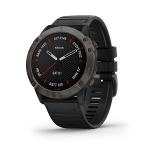
Garmin Fenix 6X
Accessories, Garmin, Navigation, Watch / GPS$ 1,649.00Ships within 3-5 daysPush new limits and explore new challenges — while adding mapping, music, intelligent pace planning and more to your workouts with the fēnix 6X selection of premium smartwatches.The rugged yet sophisticated design features a large 1.4” display that’s 36% larger than previous fēnix models. It is tested to U.S. military standards for thermal, shock and water resistance. Fit the look to your lifestyle with your choice of stainless steel or DLC coated bezels. Each Sapphire edition adds a scratch-resistant sapphire lens and premium materials. Pro Edition: Enables features on the watch such as Trendline Popularity Routing, PacePro, ski maps and the ability to preload music. Sapphire Edition: Pro Edition features, plus a scratch-resistant sapphire lens. Solar Edition: Versions with Power™ Glass lenses that harvest solar energy. --------- Features: - Wrist-based heart rate and Pulse Ox sensors add insight to your fitness activities - Dynamic PacePro™ feature helps you run smarter over various types of terrain - Preloaded ski maps for 2,000 resorts around the world - Measure running and cycling performance in ways you didn't know were possible - Sync your favourite streaming services and listen to music without your phone - Don’t be limited by battery life. Go up to 21 days between charges in smartwatch mode Case size: 51mm For full features and specifications, please visit Garmin's Website. -
Sold out
Garmin Instinct Solar
Accessories, Garmin, Navigation, Watch / GPS$ 799.00Built for the mission and designed for endurance, the Garmin Instinct Solar is equipped to keep up with your every step, no matter how far you tread. Harnessing the power of solar energy, this innovative GPS watch ensures that you never miss a beat during your outdoor pursuits. With robust durability and advanced features tailored to meet the demands of explorers and outdoor enthusiasts, the Garmin Instinct Solar is much more than just a timepiece – it's a vital companion for your most ambitious undertakings. Crafted with precision engineering and rugged sophistication, the Garmin Instinct Solar excels in providing essential navigation tools, health monitoring features, and superior battery life. Whether you're navigating challenging terrain or tracking your fitness metrics in remote locations, this exceptional watch stands ready to empower your adventures with reliable GPS functionality powered by solar technology.Introducing the Garmin Instinct Solar, a cutting-edge GPS watch designed for those who forge their own paths and embrace the spirit of adventure.
Features:
- Experience unprecedented battery life with solar charging. - Military standard toughness lets you play rough without worry. - GPS, GLONASS and Galileo. Your 3 best friends in the wild. - Train smarter with built-in sports apps right on your wrist. - Get notifications straight from your phone to your wrist. - Do more. Charge less. Get up to 54 days in smartwatch mode. Solar Battery: Variable based on sun-exposure, Instinct can provide unprecedented battery life to those that explore under the sun. Military Standard 810:Instinct is built to the U.S. military standard 810 for thermal, shock and water resistance (rated to 100 metres). Power Manager: View how various settings and sensors impact your watch?s battery life, so you can make battery-extending changes on the fly. Specs:LENS MATERIAL Power Glass? BEZEL MATERIAL Fibre-reinforced polymer CASE MATERIAL Fibre-reinforced polymer QUICKFIT? WATCH BAND COMPATIBLE Yes (22 mm) STRAP MATERIAL Silicone PHYSICAL SIZE 45 x 45 x 15.3 mm Fits wrists with a circumference of 132-224 mm DISPLAY SIZE Custom, two-window design; 0.9? x 0.9? (23 x 23 mm) DISPLAY RESOLUTION 128 x 128 pixels DISPLAY TYPE "Monochrome, sunlight-visible, transflective memory-in-pixel (MIP) WEIGHT 53 g BATTERY LIFE Smartwatch: Up to 24 days/54 days with solar* Battery Saver Watch Mode: Up to 56 days/Unlimited with solar* GPS: Up to 30 hours/38 hours with solar** Max Battery GPS Mode: Up to 70 hours/145 hours with solar** Expedition GPS Activity: Up to 28 days/ 68 days with solar* "*Solar charging, assuming all-day wear with 3 hours per day outside in 50000 lux conditions "**Solar charging, assuming use in 50,000 lux conditions WATER RATING 10 ATM MEMORY/HISTORY 16 MB -
Sold out

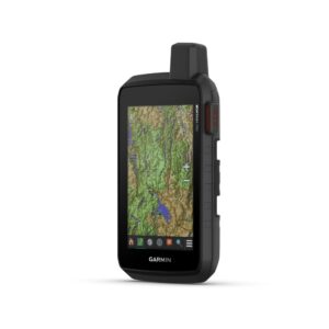
Garmin Montana 700
Accessories, Garmin, Navigation, Watch / GPS$ 999.00Explore your world with navigation you trust.With routable mapping for roads and trails, the Montana 700 handheld brings advanced outdoor features into a sturdy 5 format that's ideal for navigation on foot, bike, kayak, ATV and more. RUGGED BY DESIGN This durable, water-resistant handheld is tested to U.S. military standards and features a glove-friendly 5" touchscreen that's 50% larger than previous Montana models TOPOACTIVE AUSTRALIA AND NEW ZEALAND MAPS To navigate your adventures, use preloaded TopoActive Australia and New Zealand maps. View elevations, coastlines, rivers, landmarks and more. SATELLITE VIEWS Use direct-to-device downloads of BirdsEye Satellite Imagery (no annual subscription required) to see photo-realistic views and create waypoints based on landmarks. ABC SENSORS Navigate your next trail with ABC sensors, including an altimeter for elevation data, barometer to monitor weather and 3-axis electronic compass. ACTIVE WEATHER Use cellular connectivity to access up-to-date Active Weather forecasts through the Garmin Connect app. DOG TRACKING For hunters and trainers, this Montana syncs with compatible Astro or Alpha series handhelds (sold separately) to help track sporting dogs in the field. MULTI-GNSS SUPPORT Access to GPS, GLONASS and GALILEO satellite networks enables Montana 700 to track in more challenging environments than GPS alone. LOCATION SHARING The LiveTrack feature lets you wirelessly connect1 your device with other compatible Garmin GPS users, so they can follow your tracks, routes, waypoints and adventures. EXPEDITION MODE Trek far and wide off-grid. Use Expedition mode, an ultralow-power GPS reference, to keep Montana tracking for a week or more between recharges. BATTERY OPTIONS An internal, rechargeable lithium-ion battery pack provides more than 18 hours of battery life in GPS mode. It can also be powered with traditional AA batteries. VEHICLE MOUNTS A variety of Montana handheld-compatible mounts (sold separately) lets you adapt your navigator for use on ATVs, boats, cars, motorcycles, RVs or other vehicles. -
Sold out
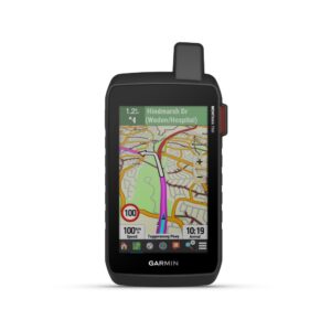
Garmin Montana 700i
Garmin, Navigation, Watch / GPS$ 1,199.00GO INTO THE WILD WITH A SATELLITE CONNECTIONTo keep adventurers in touch and on track, the Montana 700i handheld combines the flexibility of on- or off-road navigation with global messaging and interactive SOS via inReach satellite technology1. Big news. A full QWERTY keyboard lets you easily type messages. Wander wider and still stay in touch—with inReach for messaging and 24/7 SOS. Routable TopoActive Australia and New Zealand maps. Now you're free to take it off-road or on. Meets MIL-STD 810 for thermal, shock, water and vibration. Get the clear perspective of BirdsEye Satellite Imagery right to your device. Power your adventures with 18+ hours of lithium-ion battery life in GPS mode. TWO-WAY MESSAGING Exchange text messages with loved ones, post to social media, or communicate via inReach device to inReach device in the field (active satellite subscription required). INTERACTIVE SOS In case of emergency, trigger an interactive SOS message to GEOS, a professional 24/7 global monitoring and response centre (active satellite subscription required). GLOBAL CONNECTIVITY Instead of relying on cellphone coverage, now your messages, SOS and tracking are transferred via the 100% global Iridium satellite network (active satellite subscription required). INREACH WEATHER Available inReach weather forecast service provides detailed updates directly to your Montana handheld or paired devices, so you'll know what to expect en route. RUGGED BY DESIGN This durable, water-resistant handheld is tested to U.S. military standards and features a glove-friendly 5" touchscreen that's 50% larger than previous Montana models. CITY NAVIGATOR MAPS Seamlessly transition from trails to road navigation with preloaded City Navigator street mapping, which guides your drive with easy-to-follow turn-by-turn directions. TOPOACTIVE AUSTRALIA AND NEW ZEALAND MAPS To navigate your adventures, use preloaded TopoActive Australia and New Zealand maps. View elevations, coastlines, rivers, landmarks and more. SATELLITE VIEWS Use direct-to-device downloads of BirdsEye Satellite Imagery (no annual subscription required) to see photo-realistic views and create waypoints based on landmarks. ABC SENSORS Navigate your next trail with ABC sensors, including an altimeter for elevation data, barometer to monitor weather and 3-axis electronic compass. ACTIVE WEATHER Use cellular connectivity2 to access up-to-date Active Weather forecasts through the Garmin Connect app. DOG TRACKING For hunters and trainers, this Montana syncs with compatible Astro or Alpha series handhelds (sold separately) to help track sporting dogs in the field. MULTI-GNSS SUPPORT Access to GPS, GLONASS and GALILEO satellite networks enables Montana 700i to track in more challenging environments than GPS alone. TRACKING Track your location, and share it with those at home or out in the field. They'll be able to see your progress or ping your device for your GPS location and more via your web-based MapShare trip-sharing page. (Montana 700i, 750i only - satellite subscription required). EXPEDITION MODE Trek far and wide off-grid. Use Expedition mode, an ultralow-power GPS reference, to keep Montana tracking for a week or more between recharges. EXTENDED BATTERY LIFE An internal, rechargeable lithium-ion battery pack provides more than 18 hours of battery life in GPS mode. VEHICLE MOUNTS A variety of Montana handheld-compatible mounts (sold separately) lets you adapt your navigator for use on ATVs, boats, cars, motorcycles, RVs or other vehicles. -
Sold out
Garmin Montona 750i
Accessories, Garmin, Navigation, Watch / GPS$ 1,349.00SEE THE WORLD. STAY IN TOUCH. BE THE PICTURE OF ADVENTURE.The rugged Montana 750i handheld combines the flexibility of on- or off-road navigation with global messaging and interactive SOS via inReach satellite technology—plus a built-in 8-megapixel camera. Big news. A full QWERTY keyboard lets you easily type messages. Wander wider and still stay in touch with inReach for messaging and 24/7 SOS. Nav, meet cam. Put your trip pics on the map with geotags. Routable TopoActive Australia and New Zealand maps. Now you're free to take it off-road or on. Meets MIL-STD 810 for thermal, shock, water and vibration. Power your adventures with 18+ hours of lithium-ion battery life in GPS mode. TWO-WAY MESSAGING Exchange text messages with loved ones, post to social media, or communicate via inReach device to inReach device in the field (active satellite subscription required) INTERACTIVE SOS In case of emergency, trigger an interactive SOS message to GEOS, a professional 24/7 global monitoring and response centre (active satellite subscription required). GLOBAL CONNECTIVITY Instead of relying on cellphone coverage, now your messages, SOS and tracking are transferred via the 100% global Iridium satellite network (active satellite subscription required). INREACH WEATHER Available inReach weather forecast service provides detailed updates directly to your Montana handheld or paired devices, so you'll know what to expect en route. RUGGED BY DESIGN This durable, water-resistant handheld is tested to U.S. military standards and features a glove-friendly 5" touchscreen that's 50% larger than previous Montana models. BUILT-IN CAMERA Capture images of your exploits with Montana's digital 8-megapixel camera. It geotags photos with coordinates, so you can navigate back to favourite sites in the future. CITY NAVIGATOR MAPS Seamlessly transition from trails to road navigation with preloaded City Navigator street mapping, which guides your drive with easy-to-follow turn-by-turn directions. TOPOACTIVE AUSTRALIA AND NEW ZEALAND MAPS To navigate your adventures, use preloaded TopoActive Australia and New Zealand maps. View elevations, coastlines, rivers, landmarks and more. SATELLITE VIEWS Use direct-to-device downloads of BirdsEye Satellite Imagery (no annual subscription required) to see photo-realistic views and create waypoints based on landmarks. ABC SENSORS Navigate your next trail with ABC sensors, including an altimeter for elevation data, barometer to monitor weather and 3-axis electronic compass. ACTIVE WEATHER Use cellular connectivity2 to access up-to-date Active Weather forecasts through the Garmin Connect app. DOG TRACKING For hunters and trainers, this Montana syncs with compatible Astro or Alpha series handhelds (sold separately) to help track sporting dogs in the field. MULTI-GNSS SUPPORT Access to GPS, GLONASS and GALILEO satellite networks enables Montana 750i to track in more challenging environments than GPS alone. TRACKING Track your location, and share it with those at home or out in the field. They'll be able to see your progress or ping your device for your GPS location and more via your web-based MapShare trip-sharing page. (Montana 700i, 750i only - satellite subscription required). EXPEDITION MODE Trek far and wide off-grid. Use Expedition mode, an ultralow-power GPS reference, to keep Montana tracking for a week or more between recharges. EXTENDED BATTERY LIFE An internal, rechargeable lithium-ion battery pack provides more than 18 hours of battery life in GPS mode. VEHICLE MOUNTS A variety of Montana handheld-compatible mounts (sold separately) lets you adapt your navigator for use on ATVs, boats, cars, motorcycles, RVs or other vehicles. -
Sold out
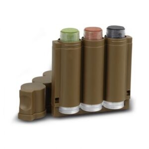
Hunters Specialties 3 Colour Speed Camo Tri Colour Makeup Kit
Accessories, Eyewear, Headwear, Hunters Specialties, Miscellaneous, Navigation$ 19.95Speed Camo allows hunters to use three individual camo sticks at once to create custom patterns, and with the Speed Camo applicator, up to two inches of coverage can be applied with one swipe. Colors include forest green, mud brown, and flat black. Speed Camo makeup is easily removed with Hunters Specialties’ handy Camo-Off® makeup remover pads, or with soap and water.Quickly apply three camo colors with one convenient pocket-sized applicator.
Features
- 3 colours - Convenient pocket-sized case - No discomfort, drying or cracking - Won't run and removes easily - Colours: Forest Green, Mud Brown, and Flat Black. - Made in U.S.A -
Sold out
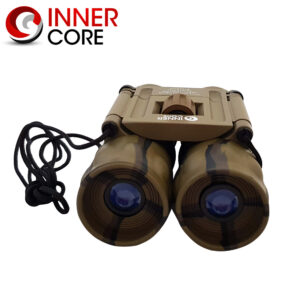
Innercore 10×25 Camo Binoculars
Accessories, Categories, Innercore, Miscellaneous, Navigation$ 29.95It also comes with a nylon carry pouch with belt loop and a lens cloth. - 10x Magnification - 25mm Objective Lens - Camouflage Colouring - Roof Prism - Aluminum Tube - Rubber Armour - Prism Type: BAK7 - Centre Focus - Includes Nylon Pouch with Belt Loop and Lens ClothInnercore 10x25 Binoculars are folding roof prism binoculars with 10x magnification and a 25mm objective lens.
-
Sold out
Silva Compass 5-6400/360 MS Silva Compass
Accessories, Categories, Navigation, Silva$ 174.59The “full-sized” base plate compass for experienced navigators – used by NATO Forces around the world. Mainly used by the infantry as a soldier’s or officer’s compass.Additional features include measuring scales for positioning (GPS), graduation in mils and degrees (6400/360), integrated adjuster for magnetic declination, magnifying lens and rubber feet for precision map work. The compass has a luminous graduation ring and markings for compass reading in the dark. Once activated by daylight/flashlight it will give light up to 4 hours of light. The included scale lanyard and slope card makes it easier to quickly make a distance judgement of your route or to plan your route in advance. FEATURES - Attachment: Detachable safety-release scale lanyard, Slope card - Declination adjustment: yes - Declination scale: yes - Clinometer: yes - Graduation: 6400° / 360° - Illumination: 4 hours after activation in light, Luminous markings - Magnifying lens: Yes - Material: Acrylic, PC/ABS, TPU - Resolution degrees / mils: 2/50 - Sapphire jewel bearing for friction-free movement of the compass needle - Scales: Baseplate: 1:25k, 1:40k, 1:50k, mm, inch, Lanyard; 1:25, / 1:50 - Silicon friction feet - Type of compass: SILVA 1-2-3, baseplate - Temperature operating range: -30 to +60 C TECH SPECS WEIGHT 50 g DIMENSIONS 126x60x13 mm MATERIAL Acrylic, PC/ABS, TPU -
Sold out
Silva Expedition 4-6400/360 MS
Accessories, Navigation, Silva$ 164.99The “full-sized” base plate compass for experienced navigators – used by NATO Forces around the world.Mainly used by the infantry as a soldier’s or officer’s compass. Additional features include measuring scales for positioning (GPS), graduated in mils and degrees (6400/360), magnifying glass and rubber feet for precision map work. Luminous compound that need to be activated by daylight/flashlight etc. Will give light up to 4 hours. Features: -NAVIGATION SYSTEM - 360 -MAGNIFIER - Yes -DECLINATION - Yes -MAP SCALES - Yes -GPS SCALES - Yes -NIGHT USE - Yes -WEIGHT - 34 g